Magnetism
Learn how to Play with this Interactive Exhibit
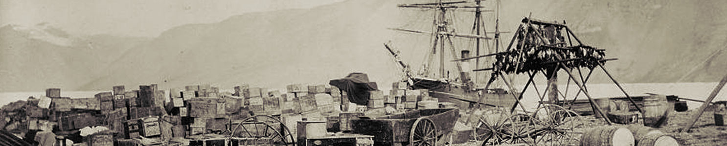
Geomagnetic Science at Fort Conger, 1881-83
As we saw in the previous section - Science and the Canadian Arctic - a focal point of scientific study for the Lady Franklin Bay Expedition, as for Arctic exploratory expeditions of the nineteenth century, was geomagnetism.
For leading nations in the Victorian era, geomagnetism represented more than the study of an aspect of the natural sciences – it was a dominant scientific discipline viewed as holding the potential to contribute to advances in global navigation, commerce, and military power.
From the point of Great Britain’s renewal of its search for the Northwest Passage in 1818, magnetic science was an important part of virtually all British expeditions to the Arctic, including the ill-fated third Arctic expedition of Sir John Franklin and the majority of the 31 expeditions sent to search for Franklin’s missing party. The Lady Franklin Bay expedition that established Fort Conger in 1881 continued in this tradition, albeit in the service of the United States, Britain's leading rival among the Arctic exploring nations.
In the nineteenth century, geomagnetism was a preoccupation for many countries but the program of magnetic science carried out at Fort Conger reflected in particular the influence of the two prominent geomagnetic scientists: Alexander von Humboldt and Carl Friedrich Gauss.
Humboldt, a Prussian geographer and naturalist, advanced a unified vision of natural phenomena and promoted the development of sophisticated instruments as a means of collecting and measuring scientific data. He placed a particular emphasis on measuring and charting the Earth's magnetic field and mapping recorded geomagnetic data around the globe. Humboldt held that all observations of natural phenomena should be taken with the finest and most modern instruments and sophisticated techniques available, and that collected and synthesized data from around the world was the basis of all scientific understanding.
Gauss, a German mathematician and physical scientist whose magnetic theories dominated the nineteenth century, classified the three categories to be followed for geomagnetic studies: declination, inclination, and intensity. The theoretical basis for these measurements was Gauss’s mathematical theory for separating the inner and outer sources of geomagnetic fields. Gauss also devised a method for taking observations in order that it could be taken the same way at the same time to enable comparisons of the data collected around the world.
Humbolt's and Gauss’s promotion of a global approach to geomagnetic studies greatly influenced the approach of Edward Sabine, the science advisor to the British Admiralty between the 1820s and 1840s. Imbued with the Victorians’ optimistic belief in the potential of accumulated data to bring progress, Sabine made geomagnetism his personal crusade and he pressed the British government to establish magnetic observatories around the world. The Royal Navy was the perfect vehicle for advancing this cause. After emerging as the world’s dominant navy following the Napoleonic Wars, the Admiralty sent its vessels to all regions of the globe, sometimes to demonstrate military power, sometimes to support commercial expansion, but also increasingly to extend the reach of British science and in particular geomagnetic science.
Science was key to Britain’s development and operated hand in glove with naval and commercial expansion. The goal of geographical discovery required sound science for safe navigation, which depended on reliable theories of geomagnetism, ocean currents, and tides.
Long before the invention of satellites and today's Global Positioning System (GPS), leading Victorian scientists believed that the study of the earth’s magnetic forces held the potential to enable development of a nineteenth century equivalent to GPS, attainable not through satellites – which had not yet been discovered – but through comprehensive geomagnetic readings. To be effective, the operative theories needed to be tested in the field with systematic, precise observations of phenomena in various parts of the world to establish both the suitability of the theory and the accuracy of its application.
By the 1880s, the United States had joined the ranks of Arctic exploring countries. While it lacked the naval power and overseas empire of Britain, the U.S. nevertheless relied heavily on overseas trade and had a vital interest in studying the natural sciences bearing upon ocean navigation and commerce. The importance of such work to U.S. vital national interests was demonstrated by the placement of the federal government’s meteorological program under the Signal Corps of the United Stated Army. Its study of weather patterns was important to the identification of weather patterns bearing upon such phenomena as storms in the North Atlantic — critical data for Trans-Atlantic navigation and international commerce.
Magnetic science was a priority for all the nations participating in the First International Polar Year, 1882-83, including the American Lady Franklin Bay Expedition. In the period before its own navy emerged as a major force, the U.S. needed to rely on international cooperation for comprehensive scientific data. The First International Polar Year, 1882-83, seemed tailor-made to address its needs.
Geomagnetic science was a major priority for the first IPY. Karl Weyprecht, the explorer and scientist who was the prime mover behind this major international scientific undertaking, promoted this emphasis and specified the types of magnetic observations and the timing for taking these readings on the expeditions that were ultimately sent to polar regions to participate in the IPY.
As well, the U.S Coast and Geodetic Survey prepared special instructions to be carefully followed in setting up magnetic observatories at both of the American IPY stations established in the North Polar Region – Fort Conger on Lady Franklin Bay in the Eastern Arctic, and Point Barrow Alaska in the West.

The Magnetic Observatory at Fort Conger
At Fort Conger, apart from mobile readings taken on the trail, all magnetic observations were taken in the magnetic observatory, which was assembled soon after the party's arrival to establish Fort Conger in August 1881.
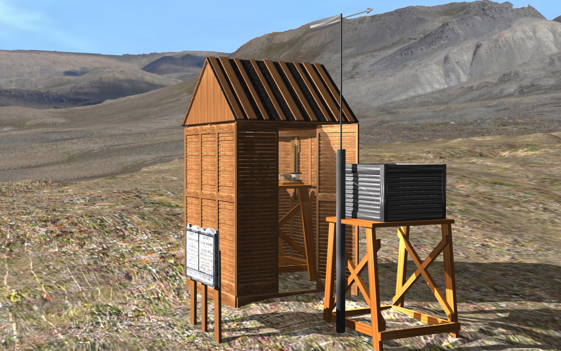
It was important to prevent any metals from distorting the magnetic readings, so the observatory needed to be set up at a remove from the main expedition house. For this building, Greely selected a site 137 metres due northeast of the main expedition house. Its dimensions were 2.13 by 3.65 metres (7 by 12 feet). Owing to the risk of distortion of magnetic observations, it was also built almost entirely of wood, with wooden pegs used to fasten the boards together, with only a few copper nails used for the leather hinges and other fastenings. The entire structure was roofed over with sod and, after the onset of winter, insulated with snow and ice.
No illustrations of the structure were published in Greely`s expedition reports, nor are there photographs of it in the collections of the expedition photographer, George Rice, at the National Archives and Records Administration in Washington, D.C. or the Explorers Club Archives in New York. However, a wood engraving based on one of Rice's photos of the site at Fort Conger shows a gable-roofed building on the far left of the image that probably is a representation of the magnetic observatory. However, the building was set back father from the main expedition house than appears in this illustration.
The most intensive observations were taken during the second year of the expedition. Greely's party built a small fireplace at the north end of the structure. For fuel,they burned both wood and the bituminous coal that the men hauled from a coal seam on the banks of Watercourse Creek, several kilometres upstream from Fort Conger. The coal was kept outside the building as Greely feared it might contain substances that could interfere with the magnetic readings.
For eight months of the year, there was sufficient daylight to take the readings without artificial light. During the four months of continuous darkness during the winter, the men illuminated the interior of the observatory with a bull’s eye lantern set on top of the scantling. The observations for declination and inclination were taken with the aid of a small copper lamp fashioned by the expedition's tinsmith.
Greely further described the observatory:
"The magnetic observatory was erected with the greatest length in the astronomical meridian. The entrance door was in the south end, and opened into a passage through which the mark could be read. The mark itself was a 2 by 4 inch scantling, the narrow or 2 inch edge to the north (true), sunk 2 feet into the ground, and secured with earth and stones, so as to render its position fixed and certain. It was distant about 300 years [274 m.] from and directly south of the magnetometer."
For all IPY expeditions, both the magnetometer and dip circle were to be mounted on separate stone piers or pedestals, built as stable bases for these instruments and set at least 12 feet apart. Each expedition was also instructed to set up a meridian or azimuth mark a short distance from the observatory so that a staff member could observe it while looking through a hole in the wall stationed inside the observatory. This mark would serve as a reference point for the astronomical observations.
Greely's party mounted the dip circle in the northwest corner of the observatory on a wooden pedestal made of scantling, which was set about two feet into the ground and strongly secured. Owing to the difficulty of building on the permafrost ground, Greely decided against erecting a brick pier and instead had the magnetometer placed on its own tripod slightly south of the centre of the building. The tripod's legs were sunk into the ground and secured to make it immobile.
Magnetic Instruments
Riddell's Instructions specified the following items of equipment for magnetic surveys:
- Nine and a half inch Dip Circle;
- Theodolite magnetometer, or Portable Unifilar magnetometer, and Portable Declinometer, with a Theodoite or Azimuthal Transit;
- Portable Declinometer and a Theodolite alone.
- Azimuth Compass and light stand.
- Sextant and artificial horizon.
The dip circle was used to determine absolute inclination, or the dip and intensity of magnetic pull, while a theodolite magnetometer and portable unifilar magnetometer were both used in determining the absolute horizontal intensity. As well, a portable declinometer and a theodolite were also used in determining absolute declination, the absolute horizontal intensity and variations of declination.
Specifications for magnetometers and associated equipment to be used in remote installations were outlined in Charles J.B. Riddell's Magnetical instructions for the use of portable instruments adapted for magnetical surveys and portable observatories, and for the use of a set of small instruments adapted for a fixed magnetical observatory, published in Great Britain in 1844. It was one of the principal reference works brought to the Arctic by the Greely expedition and describes the specified instruments, including the principal piece of equipment, the magnetometer:
Portable Declination Magnetometer
Tripod base, carrying an upper revolving plate with two projecting arms, one support the reading telescope and scale, the other a counterpoise weight.
Rectangular copper box, 3 1∕2 inches in length, 2 deep, and 1 1∕4 broad fixed to the revolving plate; the sides made of wood and attached with screws.
Glass tube 8 inches in length and 8 1∕10 outside diameter, screwed to the top of the box, and carrying a torsion circle.
Upper suspension pin, a brass cylinder 3 inches in length and about 8 3∕20ths in diameter, fitting within the socket of the torsion circle, tapered short at the lower end, and having a hole cut in the form of an inverted Y to receive the suspension thread; the pin is prevented from turning within the socket by a projecting screw-head fitting into a groove cut down its length.
Lower suspension pin, cut about 3∕4ths of an inch in length, with a similar Y aperture, a light cross bar to serve as a guide in adjusting the line of detorsion of the suspension thread to the meridian, and a circular clamp.
Stirrup and mirror. The stirrup consists of a light gun metal tube, about 3∕10ths of an inch in length, with an upright socket to receive the lower suspension pin, and a rectangular mirror 7∕8ths of an inch in breadth and 5∕10ths deep, fixed above or below the center.
Cylindrical magnet bar, 3 inches in length and 8∕10ths in diameter.
Brass plummet, with a socket to receive the suspension pin.
Reading telescope, to be attached to the end of the tripod arm.
Scale, 4 inches in length, divided to 100ths of an inch, fixed over the eye end of the telescope, at a distance from the face of the suspended mirror equal to 17.19, diminished by 2∕3rds its thickness, so that the angular value of one division many be 1'.000.
Counterpoise weight, to be attached to the shortest of the tripod arms.
Wooden block of this form [square U shape] to be placed within the copper box underneath the magnet and mirror; reel of prepared silk fibre; portable stand; and lamp.
Square magnet, spare glass tube with cement, and spare lower suspension pin.”
For International Polar Year, the Greely expedition was outfitted with a Kew pattern monofilial magnetometer for the purpose of measuring absolute and differential declination, and for determining horizontal magnetic intensity. The monofilial magnetometer featured a gold filament allowing it to swing freely according to the external magnetic influences.
Instruments for the determination of time and geographical position included a Perry Transit, a portable transit, two small theodolites, sextants and chronometers. The Perry Transit, also known as Coast Survey no. 11, was 82 centimetres long, with an aperture of 64 millimetres. The accuracy of temporal measurements more generally depended on the astronomical observations made by Israel with a transit instrument, while the time observations were taken with an electrical circuit on a chronograph sheet.
Magnetic Observations at Fort Conger
As with other IPY polar stations, magnetic observations at Fort Conger included both readings of absolute declination and inclination, as well as any observed variations from the norm. The Coast and Geodetic Survey provided blank forms for the recording of data to each of the expeditions. During the first year at Fort Conger, daily magnetic readings were taken in the observatory. This meant that every day, expedition personnel charged with these tasks would have donned their outer apparel, laced up their boots, and walked from the expedition house to record the data on standardized forms, and then brought their notes back to the house, where the data generated additional desk work.
During the actual International Polar Year, between September 1882 and 30 June 1883, a more intensive recording regimen was followed on so-called term days or days selected for intensive recording, i.e., the 1st and 15th days of every month.
Differential observations of declination were to be made with a declinometer three times a day, at 7 a.m., 3 p.m. and 11 p.m. This required an expedition member to sit inside the observatory for long shifts of several hours at a time, obliging the installation of a heater in the building for the second winter. On 18 February 1882, Sergeant Gardiner, who was a member of the magnetic recording team, recorded the lengths of their shifts. Sergeant Israel began his shift at 6 p.m. and was relieved by Gardiner at 8 a.m., when Israel resumed his shift until 7 p.m.
The only exception to the program of daily readings was during periods of intense cold, when expedition commander Adolphus Greely decided that observations could instead be taken on every other day. After the readings were taken and recorded in pencil on the Coast and Geodetic Survey forms, they were brought back to the expedition house, where Sergeant Israel refined the observations into absolute values.
During the actual designated International Polar Year, hourly observations of declination were taken at the magnetic observatory over a 13-month period, between 1 July 1882 and 1 August 1883. Using the recorded data the expedition's personnel were charged with computing the magnetic mean declination and diurnal range for each month.
During this period, magnetic observations of declination and diurnal variation were taken hourly every month for three consecutive days around the middle of the month. Over the course of the IPY, this work generated 846 observations with a resulting declination of 100o 13'.6. West of North.
During the same set of days, a set of oscillations for the determination of horizontal intensity was also to be observed. The total number of hourly magnetic observations taken over the course of International Polar Year was 8,749, while the number of observations in which disturbances registered was 1,169.
As planned by the organizers of IPY, these observations were a mandatory requirement for all 17 polar stations established during the designated year. Beyond the painstaking recording of observations, much of the labour was consumed in paper work, specifically the conversion of the differential measures of this series, meaning conversion of the individual observations into absolute values. The objective of this step was to isolate so-called disturbances from the general magnetic record and the larger goal was to identify any natural phenomena contributing to any distortions in the results. These included a magnetic disturbance occasioned by a major magnetic storm with associated spectacular aurora, 15-19 November 1882, when Greely charged his staff with taking many additional observations.
Personnel charged with the magnetic observations also took hourly observations of the dip with the dip circle between 25 September 1882 and 1 June 1883. These records also were compiled and maintained according to a strict protocol. The records were returned to the United States and eventually published by the Signal Corps in the United States in 1888.
The specific magnetometer used by the Greely expedition was a Magnetometer No. 12, made by Fauth and Company of Washington D.C., the supplier of several of the expedition's scientific instruments. A Kew Pattern monofilial magnetometer from the mid-nineteenth century is shown in Figure 2. The dip circle used at Fort Conger was a No. 19 Kew dip circle by C.F. Casella and Company of London, makers of surveying and drawing instruments. A Kew Pattern dip circle manufactured by John Dover in England between 1860 and 1880 is shown in Figure 3.
Significance of the Magnetic Work of the Lady Franklin Bay Expedition
The magnetic science carried out by the Signal Corps expedition led by Adolphus Greely represented a significant contribution to the international efforts to better understand geomagnetic forces through polar scientific research. The expedition diligently carried out its mandated responsibilities to record and measure all the major categories of magnetic data at the highest northern latitude.
Notwithstanding its difficult straits in the latter stages of the expedition, Greely's party managed to bring the records back to the United States. The U.S. Coast and Geodetic Survey comprehensively published this extensive collection in 1888.The successful completion of magnetic work by most of the 17 IPY polar stations contributed important baseline data for international magnetic science.